LiDAR in Archaeology: The Laser Revolution Revealing Lost Civilizations
The transformative power of LiDAR. Left: The impenetrable jungle of the Maya Biosphere Reserve. Right: The same area with vegetation digitally removed, revealing a complex urban landscape. (Data sourced from PACUNAM LiDAR Initiative).
Introduction – Why This Matters
For centuries, the romantic ideal of the archaeologist involved a pith helmet, a trowel, and years of painstaking excavation under a blistering sun. While fieldwork remains essential, a quiet technological revolution has shifted the very paradigm of discovery. Today, some of the most groundbreaking finds begin not on the ground, but in the air, with pulses of laser light penetrating dense forest canopies to reveal the ghostly footprints of civilizations long forgotten.
In my experience talking to archaeologists in the field, the moment a LiDAR point cloud first renders on their screen is described with near-uniform awe. It’s a “eureka” moment that instantly reframes a landscape from a wild, untamed place into a profoundly human one, etched with the geometry of ancient roads, farms, and palaces. This isn’t just about finding lost temples; it’s about understanding the scale, complexity, and environmental management of entire societies in ways previously impossible.
This article will demystify LiDAR (Light Detection and Ranging) and explore how this remote sensing technology is systematically rewriting chapters of human history from Southeast Asia to Central America. We’ll move beyond the hype to explain exactly how it works, why its impact is so profound, and how it’s guiding sustainable conservation efforts for our global heritage.
Background / Context
The challenge of jungle and forest archaeology has always been the forest itself. Dense vegetation obscures the ground, making traditional survey slow, expensive, and incredibly limited. A major city complex could lie a mere kilometer from a well-trodden path and remain completely unknown. For decades, our understanding of civilizations like the Maya was largely confined to their grand ceremonial centers—the stone pyramids and palaces that poked above the green. The vast supporting landscapes of farms, roads, reservoirs, and commoner dwellings were speculative.
Early aerial photography helped, but it still only showed the tops of trees. Satellite imagery and radar made incremental improvements. The true breakthrough came with the adaptation of Airborne LiDAR (also called Airborne Laser Scanning or ALS). While developed for topographic mapping and meteorology, archaeologists in the early 2000s began to see its potential. Pioneering work in places like the Stonehenge landscape showed it could detect incredibly subtle earthworks. But its apocalyptic moment for jungle archaeology came in 2009-2010 with a survey of a small region around the famous Maya site of Caracol in Belize. The results were staggering, revealing over 200 square kilometers of engineered landscape with breathtaking clarity.
That project proved the concept. Now, LiDAR surveys are a foundational tool, with major projects in 2024 and 2025 continuing to expand our map of the ancient human world.
Key Concepts Defined
- LiDAR (Light Detection and Ranging): A remote sensing method that uses laser pulses to measure variable distances to the Earth. By timing how long it takes for each laser pulse to return from a target, it creates a precise, three-dimensional map of the surface.
- Airborne LiDAR (ALS): The system is mounted on aircraft (planes or helicopters) or drones. It includes the laser scanner, a GPS receiver to pinpoint the aircraft’s location, and an Inertial Measurement Unit (IMU) to track its orientation.
- Point Cloud: The raw data product of a LiDAR survey—a massive collection of individual 3D points (each with X, Y, Z coordinates) representing every object the laser hit, from leaves and branches to the ground and ruins.
- Digital Elevation Model (DEM) / Digital Terrain Model (DTM): The crucial processed product for archaeologists. Through filtering algorithms, the software removes the points from vegetation (canopy, understory) to isolate only the “last returns” that hit the solid ground. This bare-earth model reveals the underlying topography, including human-made features.
- Ground-Penetrating LiDAR (or Terrestrial Laser Scanning): A ground-based system used for detailed documentation of excavations, monuments, or buildings. Not for large-area discovery but for ultra-high-resolution recording.
- Photogrammetry: A related (and often complementary) technique that creates 3D models from overlapping photographs. While excellent for detailed visual texture, it cannot penetrate vegetation like LiDAR.
Key Takeaway Box:
LiDAR vs. Traditional Survey: A Game of Scale
- Traditional Ground Survey: A team of 5 might survey 1-2 square kilometers of difficult jungle terrain in a season.
- Airborne LiDAR Survey: Can accurately map 1,000+ square kilometers in a matter of days, revealing features invisible to ground observers.
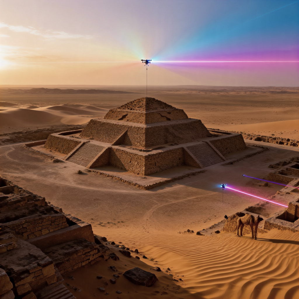
How It Works (Step-by-Step Breakdown)
- Planning & Flight Path: Archaeologists define the area of interest. A flight plan is created with parallel lines ensuring sufficient overlap (often 50-60%) in laser coverage. The LiDAR sensor is mounted on a plane or a helicopter.
- Data Acquisition (The Flight): As the aircraft flies the grid, the LiDAR unit emits hundreds of thousands of laser pulses per second downward. Each pulse can have multiple “returns” as it hits different objects (e.g., top of canopy, a large branch, understory, and finally the ground).
- Generating the Raw Point Cloud: The system’s GPS and IMU data are fused with the laser return times. Software calculates the precise location of each return point, creating a massive, unclassified 3D cloud of the entire surveyed landscape, including all vegetation and structures.
- Classification & Filtering (The Archaeological Magic): Using software like LASTools or proprietary suites, specialists apply algorithms to classify points. The goal is to separate “ground” points from “non-ground” (vegetation, buildings). This is both automated and manually refined, as complex terrain requires expert oversight.
- Creating the Digital Terrain Model (DTM): The classified ground points are interpolated to create a seamless, high-resolution model of the earth’s surface—as if every tree and bush has been digitally erased. This DTM is often visualized using “hillshade” effects, where virtual sunlight casts shadows, making subtle elevations (like ancient walls, roads, or plazas) pop out.
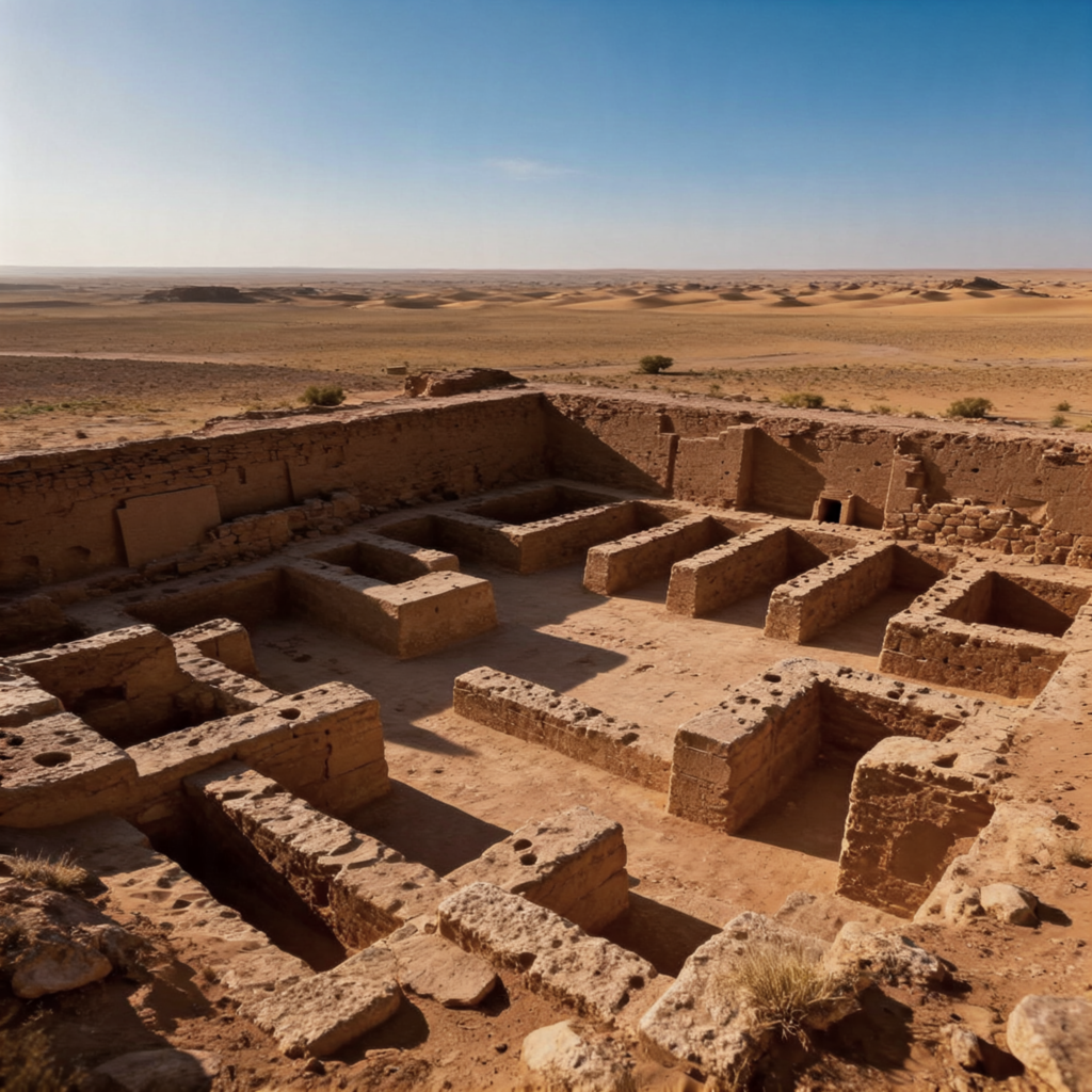
- Archaeological Interpretation: This is the human-centric phase. Archaeologists, now armed with the DTM, analyze the patterns. They identify potential structures, agricultural terraces, canals, and roadways. These features are mapped digitally and assigned for ground verification—a process called “ground-truthing.”
- Ground-Truthing & Integration: Teams navigate to the GPS coordinates of detected anomalies. They clear vegetation to confirm if a feature is natural or human-made, often initiating excavations based on the LiDAR guidance. The LiDAR map becomes the master plan for all subsequent fieldwork.
Why It’s Important
The importance of LiDAR extends far beyond the “cool factor” of finding hidden ruins.
- Redefining Scale and Complexity: It shows that ancient cities were not isolated ceremonial centers but vast, low-density urban complexes with integrated suburbs, infrastructure, and intensive agricultural systems. The 2018 PACUNAM LiDAR Initiative in Guatemala revealed over 60,000 previously unknown Maya structures in a 2,100 sq km area, suggesting a population in the millions—far higher than previously estimated.
- Understanding Human-Environment Interaction: By revealing raised fields, canal networks, and terraces, LiDAR provides a blueprint of how past societies managed their environment, especially water in drought-prone regions. This offers critical lessons in sustainability.
- Conservation and Threat Mitigation: LiDAR provides a complete baseline map of archaeological resources. This is vital for protecting sites from deforestation, urban sprawl, and looting. Governments and NGOs use these maps to designate protected zones.
- Democratizing the Past: The visual power of LiDAR maps captures public imagination, fostering support for heritage conservation. It also allows global researchers to collaborate on digital landscapes without needing to be physically present at the site.
- Saving Time and Resources: It directs limited excavation budgets and field time to the highest-potential targets, making archaeological research exponentially more efficient and less destructive.
Sustainability in the Future
LiDAR is not just about revealing the past; it’s a tool for safeguarding our future.
- Forest as Heritage: By proving that “pristine” rainforests like the Amazon are, in fact, profound cultural landscapes shaped by millennia of human habitation, LiDAR strengthens the argument for their conservation. It adds a powerful cultural heritage dimension to the ecological one. A 2025 study in the Brazilian Amazon used LiDAR to identify vast networks of “dark earth” (anthropogenic soils) and settlement patterns, providing indigenous communities with data to support land rights claims against deforestation.
- Climate Change Resilience: Understanding ancient water management systems in Maya or Khmer societies can inform modern strategies for drought and flood management in similar climates.
- Non-Invasive Documentation: For fragile sites threatened by erosion, tourism, or conflict, LiDAR provides a perfect, non-invasive digital record. This is a cornerstone of “preservation by record.”
- Guiding Sustainable Development: In countries like Cambodia and Belize, LiDAR maps are used by planning authorities to route infrastructure projects away from sensitive, previously unknown archaeological areas, preventing costly delays and destruction.
Common Misconceptions

- “LiDAR sees through the ground like X-ray vision.” FALSE. LiDAR only maps the surface it hits. It cannot see structures buried deep underground. It reveals mounds, depressions, and foundations that are part of the surface topography.
- “The computer does all the work and instantly shows cities.” FALSE. The raw data is a chaotic point cloud. Expert processing, filtering, and interpretation are lengthy, skilled tasks. The “aha!” images are the final product of weeks of work.
- “LiDAR makes field archaeologists obsolete.” FALSE. It makes them more crucial than ever. LiDAR provides the map, but only ground-truthing—physical examination, excavation, and material analysis—can provide the context, date the finds, and reveal the human stories. It transforms the archaeologist’s role from prospector to targeted investigator.
- “Every anomaly on a LiDAR map is an ancient ruin.” FALSE. Natural features, modern agricultural terracing, or logging roads can create patterns that need careful discrimination. Experience is key to accurate interpretation.
Recent Developments (2024-2025)
- Drone LiDAR Proliferation: The use of drone-mounted LiDAR has exploded. Drones offer lower cost, higher resolution for smaller areas, and access to logistically challenging terrain (steep slopes, small islands). Projects in the Bolivian Amazon and remote Pacific islands are leveraging this.
- AI and Machine Learning Integration: Researchers are training AI algorithms to automatically identify and classify archaeological features in point clouds (e.g., “find all rectangular platforms of a certain size”). This speeds up the analysis of the ever-growing datasets. A 2024 paper in Science Advances demonstrated an AI that could identify Amazonian earthworks with over 90% accuracy.
- Multispectral and Hyperspectral LiDAR: Experimental systems that not only map shape but also capture spectral data about the chemical composition of surfaces, potentially identifying areas of ancient burning, specific building materials, or crop types.
- The “Lidar for the World” Initiative: A growing consortium of universities and institutions is advocating for and coordinating the systematic LiDAR mapping of all the world’s forested regions within a decade, treating it as a global cultural heritage priority.
Success Stories
1. The Khmer Empire’s Hidden Grid (Cambodia):
Beyond the temples of Angkor Wat, LiDAR revealed a sprawling, planned urban landscape covering ~3,000 sq km. It showed an intricate grid of roads, canals, and neighborhood temples, confirming historical descriptions of Angkor as the world’s largest pre-industrial city. Crucially, it revealed a sophisticated water management network of massive reservoirs and channels that ultimately may have contributed to its vulnerability to climate change.
2. The “Megalopolis” in the Maya Biosphere Reserve (Guatemala):
The PACUNAM LiDAR Initiative is the flagship success. Its first phase in 2018 was a bombshell, showing a landscape densely occupied and engineered. It revealed defensive walls, fortresses, and highways, indicating a society with high levels of organization and, at times, conflict. Subsequent phases continue to fill in the map, forcing a complete rewrite of Maya demography and socio-political structure.
3. The Mound Clusters of the Amazon:
Long thought to be a “counterfeit paradise” incapable of supporting complex societies, LiDAR surveys in parts of the Bolivian Llanos de Mojos and Brazilian Amazon have revealed complex networks of ceremonial mounds, sunken plazas, and aligned roadways dating back over 1,500 years. This proves that large, structured societies flourished by profoundly shaping their environment.
Real-Life Examples
- Angkor Wat, Cambodia: LiDAR showed that the temple was integrated into a city with a rigid grid of roads and canals, and revealed a previously unknown, buried spiral structure near the central temple.
- Caracol, Belize: The pioneering project that started it all, mapping causeways, agricultural terraces, and thousands of residential compounds.
- Stonehenge, England: While not jungle, LiDAR here demonstrated its ability to find subtle ritual monuments and earthworks, creating a comprehensive sacred landscape map.
- Valley of the Kings, Egypt: Terrestrial LiDAR is being used to create ultra-precise models of tombs for conservation, monitoring decay, and creating virtual tours.
Conclusion and Key Takeaways

LiDAR technology has irrevocably changed the face of archaeology. It has transitioned from a novel experiment to an indispensable tool in the archaeologist’s kit. By granting us a “forest-penetrating eye,” it has done more than discover lost cities; it has revealed the true anatomy of ancient civilizations—their scale, their ingenuity, and their intimate relationship with the environment.
The key takeaway is that we are living in a golden age of discovery, not because we are digging more, but because we are seeing more. The blank spaces on the map of human history, particularly in the tropical regions that cover much of our planet, are being filled in at an unprecedented rate. This knowledge is not just academic; it empowers indigenous communities, informs conservation, and reminds us of both the ingenuity and the fragility of complex societies.
Final Thought from the Field: What I’ve found is that the most exciting implication is the democratization of discovery. With global LiDAR datasets increasingly made public, a student in Berlin or a researcher in Buenos Aires can explore the digital landscape of Angkor or the Amazon, making their own observations. This collaborative, open future is perhaps LiDAR’s greatest gift to the story of humanity.
FAQs (Frequently Asked Questions)
1. How deep underground can LiDAR see?
LiDAR cannot penetrate the ground at all. It measures the surface. It reveals archaeological features that are expressed in the topography, like the foundations of a wall that create a slight ridge, or a buried ditch that causes a subtle depression.
2. What’s the difference between LiDAR on a plane vs. a drone?
Plane/helicopter-based LiDAR covers vast areas (hundreds to thousands of sq km) efficiently. Drone LiDAR covers smaller areas (tens of sq km) but at much higher point density (more detail), is cheaper for targeted projects, and can fly below clouds.
3. How much does an archaeological LiDAR survey cost?
Costs vary wildly. A large regional survey by plane can cost hundreds of thousands of dollars. A targeted drone survey for a specific site might be in the $10,000-$50,000 range. Costs are dropping as technology becomes more common.
4. Can LiDAR be used underwater?
Yes, but it’s a different technology called bathymetric LiDAR, which uses a green laser that can penetrate water. It’s used for mapping coastal archaeology, like submerged landscapes from the last Ice Age.
5. How do you know a LiDAR feature is ancient and not modern?
Shape, pattern, and context. Ancient agricultural terraces have specific forms. Rectangular platforms align with known architectural styles. Ground-truthing is essential: if you dig and find ancient pottery and no modern debris, you have confirmation.
6. What software do archaeologists use to analyze LiDAR data?
Common tools include ArcGIS Pro, QGIS (open source), LASTools, and proprietary software from LiDAR hardware manufacturers like Leica or RIEGL.
7. Has LiDAR found any “legendary” lost cities like El Dorado?
It has found cities that were mythical in their scale. While no single “El Dorado” has appeared, LiDAR has shown that the Amazon was dotted with numerous significant, complex settlements, which collectively reshape the legend’s premise.
8. Does bad weather affect LiDAR surveys?
Yes. Clouds and heavy rain can block laser pulses. Flights are planned for the dry season and clear weather whenever possible.
9. Can anyone access archaeological LiDAR data?
It’s becoming more common. Many research projects, especially publicly funded ones, release DTMs after a certain period. The Open Heritage 3D initiative and university repositories are good places to look.
10. What’s the “point density,” and why does it matter?
Point density is the number of laser points per square meter (e.g., 10 pts/m² vs. 50 pts/m²). Higher density means more detail, potentially revealing smaller features like postholes or pottery scatters, but it generates more data and is more expensive to collect and process.
11. How does LiDAR compare to ground-penetrating radar (GPR)?
They are complementary. LiDAR maps surface features over huge areas. GPR uses radar waves to detect subsurface structures over small, targeted areas. An archaeologist might use LiDAR to find a site and GPR to investigate a specific building within it.
12. Are there ethical concerns with LiDAR?
Yes. Mapping sensitive areas can reveal sites to looters. Data must be carefully managed. Furthermore, discoveries can impact the land rights of indigenous communities; ethical practice requires their involvement from the start. For more on ethical frameworks in research, see our partner site’s guide on building successful partnerships.
13. What is “ground-truthing”?
The physical act of visiting the coordinates of a LiDAR-identified anomaly to verify what it is, clean it, survey it, and often excavate it. It’s the critical link between digital data and archaeological reality.
14. Can LiDAR help with climate change studies?
Absolutely. By revealing ancient coastlines, river courses, and agricultural responses to drought, it provides long-term data on human adaptation (or collapse) in the face of environmental change.
15. What’s the future of LiDAR in archaeology?
The future is ubiquitous, automated, and integrated. More landscapes will be mapped. AI will handle initial feature detection. LiDAR data will be routinely combined with satellite spectroscopy, ground geophysics, and legacy excavation data in unified digital platforms.
16. How long does it take to process LiDAR data?
For a large survey, processing (from point cloud to interpretable DTM) can take a small team several weeks to months, depending on the terrain’s complexity and the desired level of detail.
17. Are there any health or environmental risks from the lasers?
Airborne LiDAR uses eye-safe lasers. The environmental impact is minimal—essentially just the carbon footprint of the aircraft, which is far less than the impact of large-scale, blind deforestation or development that might otherwise destroy undiscovered sites.
18. What was the biggest surprise from LiDAR so far?
The sheer density of settlement in the Classic Maya world and the Amazon. The landscapes were not empty wildernesses dotted with a few cities, but continuously managed, inhabited spaces.
19. Can LiDAR be used in deserts or open areas?
Yes, and it’s very effective. It can find incredibly subtle traces like old river channels (palaeorivers), fossilized dune systems where people camped, or slight trackways. Its ability to create hyper-accurate elevation models is valuable anywhere.
20. How do I become an archaeologist who uses LiDAR?
Pursue a degree in archaeology, anthropology, or geography with a focus on geospatial sciences (GIS, remote sensing). Gain proficiency in GIS software. Many graduate programs now offer specializations in digital archaeology or archaeological prospection.
21. Does World Class Blogs cover other cutting-edge technologies?
Absolutely. We explore innovations across fields. For instance, you can learn about the frontiers of AI in our dedicated section on Artificial Intelligence & Machine Learning.
22. What happens to a site after LiDAR finds it?
It is documented, assessed for significance, and ideally, protected. Excavation is selective and targeted. The primary goal is often conservation in situ, using the LiDAR map as a management tool.
23. Can LiDAR date a site?
No. LiDAR reveals spatial form, not age. Dating comes from materials (pottery, charcoal) recovered during ground-truthing and excavation, analyzed through methods like radiocarbon dating.
24. What’s the smallest feature LiDAR can detect from a plane?
Under ideal conditions with high point density, features as small as 20-30 cm in size (like a single large stone or a drainage ditch) can be detected.
25. How does this relate to modern business or non-profit work?
The principles of using technology for efficient discovery, data-driven planning, and sustainable management are universal. Non-profits in heritage conservation use these tools, and the analytical mindset is valuable. Explore how organizations operate in our Nonprofit Hub.
About Author
This article was authored by the World Class Blogs Editorial Team, comprising researchers and writers passionate about making complex scientific and technological breakthroughs accessible and engaging to a global audience. Our mission is to provide deeply researched, accurate, and actionable content that bridges the gap between expert knowledge and public understanding. We believe in the power of clear explanation to foster curiosity and informed dialogue. Learn more about our mission and team at our About Us page.
Free Resources

- Open LiDAR Data Portals:
- OpenTopography: A hub for lidar topography data, including some archaeological surveys.
- NOAA Digital Coast: For US coastal and bathymetric lidar data.
- UK Environment Agency: Free, open LiDAR of England.
- Software to Explore:
- QGIS: Free, open-source GIS software. With tutorials, you can view and analyze public LiDAR DTMs.
- CloudCompare: Free software for visualizing and processing 3D point clouds.
- Further Reading:
- “The Next Revolution: How LiDAR is Changing Archaeology” (National Geographic, 2024 Update).
- PACUNAM LiDAR Initiative Official Publications.
- For insights on managing complex projects and data, akin to large LiDAR surveys, consider this guide on Global Supply Chain Management.
Discussion
We’d love to hear your thoughts! What lost civilization or region fascinates you the most? How do you think technology will continue to change our understanding of the past? Have you ever explored a LiDAR map online? Share your questions and insights. For further conversation or inquiries, feel free to reach out via our Contact Us page. For more articles spanning a wide range of topics, visit our main Blogs category or discover our Focus areas.